Unfortunately, this deal has expired 2 days ago.


*
81°
Posted 2 August 2023
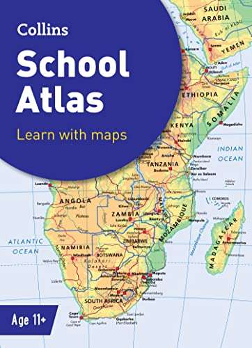
Collins School Atlas
Shared by
akil_mayet
Joined in 2015
3,313
335
About this deal
This deal is expired. Here are some options that might interest you:
Free shipping for prime members
Delivery charges apply for non prime unless basket value is over £25
The must-have atlas for pupils aged 11-14
Fully updated for 2022-2023, this world atlas is designed to support Key Stage 3 students aged 11-14 years in developing their geographical and mapping skills. The content follows requirements of the National Curriculum and has been reviewed by educational experts.
A clear, easy-to-read ‘Introducing Atlas Maps’ section explains key information and encourages development of map, atlas and data handling skills. Comprehensive reference maps include facts, photos, map keys and engaging descriptive text. An extended ‘World’ section covers all the global issues required by the National Curriculum, such as population, climate change and environmental issues.
· Fully updated for the 2022-2023 school term
· Clearly explains key information such as latitude and longitude, scale, projections, distance, symbols, satellite images and GIS
· Includes focus country studies and covers global issues required by the National Curriculum
· Map coverage of the United Kingdom and Ireland, Europe, Asia, Africa, North America, South America, Oceania and Antarctica
· Ideal for classroom use or home learning
· Suitable for ages 11-14 (KS3 and S1-S2)
This atlas is also available as an ebook (ISBN 9780008487140). The next atlas in the series is the Collins Student Atlas (ISBN 9780008430238).
 More details at
 Community Updates
Edited by a community support team member, 2 August 2023


4 Comments
sorted byHeaven knows they might start thinking there are places to go outside their bedrooms. Online is great for homework but if they take an interest in a physical copy the benefits could make all the difference.